


Saturday, December 20, 2008

Friday, December 19, 2008
Mount St. Helens
October 11th to 15th
Past Mt Rainier, we head through national forest land on little used route 25. This is definitely tree country....

The road traffic changes....

Campgrounds are absent and we rough camp at the roadside and get a fire going.

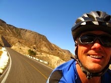
Ascending we hit the snow line and the air is a tad chilly....

Route 99 leads directly towards the blasted, flattened cone of Mount St Helens, but floods last winter have left the last 10 miles impassable where the road was washed away. This is a view from 14 miles away and we wonder just how massive this bohemouth would look from up close....

Miles of valley below recover from the massive 1980 eruption that left 57 people dead. 250 homes, 47 bridges, 15 miles (24 km) of railways, and 185 miles (298 km) of highway were also destroyed. The eruption caused a massive debris avalanche, reducing the elevation of the mountain's summit from 9,677 feet (2,950 m) to 8,365 feet (2,550 m). Stumps of trees toasted in the catastrophy still stand sentinel over lush new growth....

Descending, the air grows damp and ghostly trees emerge eerily from the gloom...

A real contrast to the autumnal colour as we near Battle Ground near the Oregon border....

Oregon's reputation for cycle frienliness gets off to a great start with a purpose built cycle lane splitting a 6 lane highway on the I-205 bridge.

Past Mt Rainier, we head through national forest land on little used route 25. This is definitely tree country....

The road traffic changes....

Campgrounds are absent and we rough camp at the roadside and get a fire going.

Ascending we hit the snow line and the air is a tad chilly....

Route 99 leads directly towards the blasted, flattened cone of Mount St Helens, but floods last winter have left the last 10 miles impassable where the road was washed away. This is a view from 14 miles away and we wonder just how massive this bohemouth would look from up close....

Miles of valley below recover from the massive 1980 eruption that left 57 people dead. 250 homes, 47 bridges, 15 miles (24 km) of railways, and 185 miles (298 km) of highway were also destroyed. The eruption caused a massive debris avalanche, reducing the elevation of the mountain's summit from 9,677 feet (2,950 m) to 8,365 feet (2,550 m). Stumps of trees toasted in the catastrophy still stand sentinel over lush new growth....

Descending, the air grows damp and ghostly trees emerge eerily from the gloom...

A real contrast to the autumnal colour as we near Battle Ground near the Oregon border....

Oregon's reputation for cycle frienliness gets off to a great start with a purpose built cycle lane splitting a 6 lane highway on the I-205 bridge.

Wednesday, December 17, 2008
Washington - Mount Rainier
October 9th to 11th
Leaving the Seattle cityscape behind, we head inland... and uphill.
We also hit our first snag - Interstates with no cycle friendly shoulder, and roadworks. Bikes become passengers, we the beasts of burden as we carry bikes and luggage over the debris....

Late in the season, campgrounds are now closed, ensuring we get the best pitch in the place....

This is bear country and panniers are hoisted aloft overnight. I worry that making food harder to reach, just makes us look more likely snack material...

The terrain begins to grow huge in scale....

As we get a glimpse of the distant snow capped peak of the volcano Mount Rainier, majestic at 14,411 feet (4,392 m)....

My rookie earns her stripes on her first pass and is promoted to "junior", a proud moment for both of us....

The descent is a blur of speeding trees and sweeping bends, before we earn the reward of motel bed for the night. Room with a view...

Monday, December 15, 2008
Washington State
October 2nd to 8th
Entering the US by ferry is a breeze. You still have to leave your fingerprints, but at least the customs officials behave like human beings and actually made us feel welcome entering the country. Contrast airport immigration... I need to investigate ferry crossings from the UK when I next visit.
We leave Anacortes via "Deception Pass" - a bridge to Whidbey Island - second largest island in the lower 48 states. Captain Vancouver exploring the region by ship in 1792 assumed the island to be a peninsula to the mainland. Upon discovering his mistake, he named the body of water separating the 2 lands Deception Pass. Conveniently, a bridge has been built since then...

We cycle south through moistly forested terrain which undulates sufficiently to keep the legs warm... It's all very picturesque and a good choice of routes to Seattle.

We cross back to the mainland on the Mukilteo ferry amidst a swarm of sea birds no doubt attracted to the feast churned up in the ferry propeller's wake. On other occasions whale and dolphin accompany crossings, sadly not today.
Time presses as we hit busy I99 heading south into downtown Seattle. We have a date to meet my brother and amazingly we manage to arrive within 3 hours of the appointed hour. I argue that 3 hours behind schedule out of 18 days by bike is close enough to be considered "on time". My brother struggles with these new definitions of time keeping, but he'll catch on....
Tourist time!! We hit the sights.... Brother Matthew and Sue....

Pike place market replete with artisans producing a range of souvenirs, and fish throwing sea food vendors....

We take an underground tour of the old city, constructed when Seattle was a supply town to miners struck by gold fever. Lacking adequate sanitation, town planners decided to construct a new city above the old one, a process taking a number of years and leading to such anomalies as roads being temporarily 30 feet above sidewalks, making crossings slightly hazardous - even resulting in several deaths. Present day buildings bizarrely show former windows and door ways scythed in half by the current street level. It's an excellent and irreverent tour run with a comedy slant - well worth a look.
We visit the Seattle's signature space needle building constructed for the 1962 World trade fair for stunning city views and impressive exhibition....

Underwater at the aquarium....

Of course we drink the obligatory coffee at Starbucks... Seattle is a great city and it's great to see my brother again for a few days....
Subscribe to:
Posts (Atom)